
Mineral resource and
mineral reserve statement
Introduction
The Mineral Resource and Mineral Reserve of Tharisa Minerals has been prepared under the guidance of the Competent Persons in accordance with the requirements of the South African Code for the Reporting of Exploration Results, Mineral Resources and Mineral Reserves, 2016 ('SAMREC Code'). The estimates are as of 30 September 2018.
The previous declaration of the Mineral Resource and Reserve was dated September 2017. The current Mineral Resource declaration relies on the geological model and resource modelling of September 2016 for the MG Chromitite Layers (as there are no additional drill intersections) and the June 2018 modelling for the UG1 Chromitite Layer (45 additional drill intersections for 4 504 m) and the end of FY2018 mining faces. The Mineral Reserve declaration is based on the latest pit design and LOM schedule.
Overview
Since the commencement of operations at the Tharisa Mine, additional geological information has been obtained from observation in the operating pits and resource drilling. During FY2016, an additional 35 diamond drill boreholes were logged and sampled. This borehole information was included in the updated Mineral Resource and Reserve statement. These boreholes are located immediately ahead of the current highwall, along the full strike length of the mine. The results from the samples confirmed the geological assumptions as well as the grades of the various chromitite layers, providing additional confidence in the mining operations. Observations on the operation confirm the details observed from the drilling.
Over a period of three years, various drilling campaigns, 46 boreholes were drilled into the area underlain by the UG1 Chromitite Layer. This data was used to model the UG1 Chromitite Layer and declare a Mineral Resource in June 2018.
The Mineral Resource and Mineral Reserve information in the tables on the following pages is based on information compiled by the Competent Persons (as defined by the SAMREC Code).
Definitions
The declaration of the Mineral Resource and Reserve has been undertaken in terms of the guidelines of SAMREC Code (2016 Edition).
Location
The Tharisa Mine is located 35 km east of Rustenburg and 120 km northwest of Johannesburg in the North West province of South Africa.
Statement by Competent Persons
Ken Lomberg of Pivot Mining Consultants Proprietary Limited (previously Coffey Mining South Africa Proprietary Limited) who is the Competent Person for the Mineral Resource declaration, registered with the South African Council for Natural Scientific Professions (Private Bag X540, Silverton, 0127, Gauteng province, South Africa), registration number 400038/01. He holds a BSc (Hons) Geology, BCom and MEng (Mining Engineering). Mr Lomberg is a geologist with 32 years' experience, including the Mineral Resource estimation in respect of PGM and chromitite in the Bushveld Complex.
The Mineral Reserve declaration is by Jaco Lotheringen of Ukwazi Mining Solutions who is the Competent Person for the Mineral Reserve declaration. He holds a BEng (Mining). He is registered with the Engineering Council of South Africa (ECSA, Private Bag X691, Bruma, South Africa), registration number 20030022. He is a Principal Mining Engineer with appropriate experience in the estimation, assessment and evaluation of relevant Mineral Reserves based on the class of deposit and mining methodology.
The Company has written confirmation from Ken Lomberg and Jaco Lotheringen that the information disclosed is in compliance with the SAMREC Code and that they have consented to the inclusion of this information in the form and context in which it appears.
Mining Rights summary
Tharisa Minerals holds a Mining Right, granted by the DMR (then the DME) in terms of the MPRDA on 19 September 2008, for a period of 30 years, to various portions of the farm 342 JQ and the whole of the farm Rooikoppies 297 JQ. On 13 August 2009, the Mining Right was registered in the Mining and Petroleum Titles Registration Office, under Reference No 49/2009(MR).
In July 2011, an application was granted in terms of section 102 of the MPRDA, to amend the existing Mining Right by the addition of Portions 96, 183 and 286 of the property 342 JQ to the Mining Right 49/2009(MR).
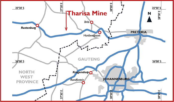
Figure 1: Location of the Tharisa Mine
Mineral Resource
Geology and mineralisation
The Tharisa Mine is situated on the south-western limb of the Bushveld Complex, and is underlain by the Middle Group ('MG') and Upper Group ('UG') Chromitite Layers straddling the boundary between the Marikana and Rustenburg facies. The MG Chromitite Layers outcrop on the property striking roughly east to west with a gentle change in strike to NW-SE in the far west. The layers dip at between 9° and 15° to the north. Towards the western extent of the outcrop, the dip is steeper. The stratigraphy typically narrows to the west and the dip steepens. The dip typically shallows out at depth across the extent of the mine area.
The MG Chromitite Layer package consists of five groups of chromitite layers, being the MG0 Chromitite Layer at the bottom, followed by the MG1 Chromitite Layer, the MG2 Chromitite Layer (sub-divided into C, B and A chromitite layers), the MG3 Chromitite Layer and the MG4 Chromitite Layer (sub-divided into 4(0), 4 and 4A chromitite layers). The layers between the chromitite layers frequently include stringers or disseminations of chromite. The MG Chromitite Layers at the Tharisa Mine are a typical stack of tabular deposits.
The structural interpretation of the Tharisa Mine geology is based on the aeromagnetic data, the available drilling and observations in the operating open pits. The only significant fault is a steeply dipping NW-SE trending normal fault with a downthrow of less than 30 m to the east. This fault occurs only on the far north-eastern corner of the property and will have little effect on mining of the MG Chromitite Layers on the mine. A NE-SW sub-vertical dyke of some 10 m thickness was exposed in the east pit. The dyke is not expected to have a major impact on mining. The only other major feature of interest is the Spruitfontein upfold or pothole which is located on the properties immediately west of the mine. It affects the UG2 Chromitite Layer as well as the rest of the critical zone below. No new major structural features have been exposed by the current mining operation.
The Mineral Resource estimate was completed over the Mining Right of Tharisa Minerals to a depth of 750 m for the MG Chromitite Layers. The UG1 Chromitite Layer Resource Estimate was limited to the area within the planned pit perimeter.
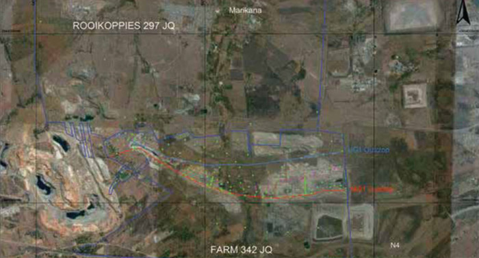
Figure 2: Image of the Tharisa Mine plan showing borehole locations and outcrop positions of UG1 and MG1 chromitite layers
The previous declaration of the Mineral Resource and Reserve was dated September 2017. The current Mineral Resource declaration relies on the geological model and resource modelling of September 2016 (as there are no additional drill intersections) for the MG Chromitite Layers and the geological model and resource modelling of May 2018 for the UG1 Chromitite Layer and the end of FY2018 mining faces.
In-pit drilling continues for the purposes of mining operations, mine planning and grade control. Additional resource drilling has been planned for the next financial year.
Prior to the estimation, the data was collated and verified with the necessary quality controls for logging, sampling and assays being used. The Mineral Resource estimate was undertaken on each chromitite layer and interburden independently. Each element was estimated separately. Changes to the Mineral Resource declaration are due to the production during the previous financial year, a revision of the UG1 Chromitite Layer declaration and a revision of the Inferred Resource.
Tharisa Minerals Resource at 30 September 2018 is reported inclusive of Mineral Reserve.

Figure 3: Map of the location of the Tharisa Mine
Mineral Resource estimate
| 2018 | Measured | Indicated | Inferred | Total | |||
|---|---|---|---|---|---|---|---|
| Tonnes | Mt | 62.82 | 112.35 | 685.49 | 860.66 | ||
| 6PGE + Au grade | g/t | 1.78 | 1.70 | 1.55 | 1.59 | ||
| 5PGE + Au grade | g/t | 1.73 | 1.65 | 1.50 | 1.54 | ||
| 3PGE + Au grade | g/t | 1.32 | 1.25 | 1.14 | 1.17 | ||
| Cr2O3 grade | % | 23.69 | 22.57 | 20.11 | 20.11 | ||
| Contained 6PGE + Au | Moz | 3.61 | 6.16 | 34.26 | 43.02 | ||
| Contained 5PGE + Au | Moz | 3.49 | 5.94 | 33.05 | 42.48 | ||
| Contained 3PGE + Au | Moz | 2.67 | 4.52 | 25.17 | 32.35 | ||
| Contained Cr2O3 | Mt | 14.88 | 25.36 | 137.84 | 173.06 | ||
| 2017 | |||||||
| Tonnes | Mt | 67.94 | 114.47 | 685.07 | 867.48 | ||
| 6PGE + Au grade | g/t | 1.79 | 1.68 | 1.55 | 1.59 | ||
| 5PGE + Au grade | g/t | 1.73 | 1.62 | 1.50 | 1.53 | ||
| 3PGE + Au grade | g/t | 1.33 | 1.23 | 1.14 | 1.17 | ||
| Cr2O3 grade | % | 23.78 | 22.34 | 20.08 | 20.67 | ||
| Contained 6PGE + Au | Moz | 3.9 | 6.2 | 34.2 | 44.3 | ||
| Contained 5PGE + Au | Moz | 3.8 | 6.0 | 33.0 | 42.8 | ||
| Contained 3PGE + Au | Moz | 2.9 | 4.5 | 25.1 | 32.6 | ||
| Contained Cr2O3 | Mt | 16.16 | 25.58 | 137.59 | 179.32 |
Mineral Reserve declaration
The Mineral Reserve estimate for September 2018 was based on a revised, updated LOM. This re-estimation was underpinned by an updated mining model and incorporates the current economic conditions, current on-mine mining methodology and survey depletion. Various technical aspects were considered in the mine design and schedule including the determination of the economic pit limits, geotechnical parameters, mining methodology and sequence, pit access, ramp placement, equipment capability, production rates and practical mining considerations. The mining-related modifying factors applied included geological losses, mining loss, mining dilution and metallurgical recovery. The difference between the 2017 and 2018 Mineral Reserve estimation is due to depletion from the previous declared Mineral Reserve.
The LOM plan was designed to extract the MG Chromitite Layers, firstly from open pit mining to a maximum depth of 200 m and subsequently from underground extraction (MG2 and MG4 Chromitite Layers) by means of a bord and pillar mining method.
The Mineral Reserve tonnage decreased by 5.2% as a result of depletion by mining and treatment. The contained chrome decreased by 5.4% and the contained PGMs (3PGE + Au) ounces by 5.4%. A small proportion (2.0%) of Inferred Mineral Resource (in the Far West pit) was included in the open pit LOM plan but was not considered as part of the Mineral Reserve estimate. The Inferred Mineral Resource was included in the underground section of the mine plan, but not included as part of the Mineral Reserve estimate. If excluded from the underground mine plan, the underground project may not be feasible. The Mineral Reserve declared for the underground project was derived from the Indicated Mineral Resource portion that was included in the underground LOM plan. The underground section is planned to ramp up during the final phase of the open pit operation.
A feasibility study was completed in 2013 for the underground mining of the MG2 and MG4 Chromitite Layers from the limit of the open pit highwall. The Mineral Reserve for the underground section extends to a maximum depth of 270 m, however, the underground LOM can be expected to extend to a maximum depth of 700 m, pending further field work on study work.
| Open pit 2018 | Proved | Probable | Total | |||
|---|---|---|---|---|---|---|
| Tonnes | Mt | 47.7 | 26.5 | 74.2 | ||
| 5PGE + Au grade | g/t | 1.39 | 1.38 | 1.39 | ||
| 3PGE + Au grade | g/t | 1.06 | 1.06 | 1.06 | ||
| Cr2O3 grade | % | 19.2 | 18.3 | 18.9 | ||
| Contained 3PGE + Au | Moz | 1.6 | 0.9 | 2.5 | ||
| Contained Cr2O3 | Mt | 9.2 | 4.8 | 14.0 | ||
| Open pit 2017 | ||||||
| Tonnes | Mt | 51.8 | 26.6 | 78.3 | ||
| 5PGE + Au grade | g/t | 1.39 | 1.38 | 1.39 | ||
| 3PGE + Au grade | g/t | 1.07 | 1.06 | 1.06 | ||
| Cr2O3 grade | % | 19.3 | 18.3 | 18.9 | ||
| Contained 3PGE + Au | Moz | 1.8 | 0.9 | 2.7 | ||
| Contained Cr2O3 | Mt | 10.0 | 4.8 | 14.8 |
| Underground 2018 | Proved | Probable | Total | |||
|---|---|---|---|---|---|---|
| Tonnes | Mt | – | 18.7 | 18.7 | ||
| 5PGE + Au grade | g/t | – | 1.52 | 1.52 | ||
| 3PGE + Au grade | g/t | – | 1.17 | 1.17 | ||
| Cr2O3 grade | % | – | 19.3 | 19.3 | ||
| Contained 3PGE + Au | Moz | – | 0.7 | 0.7 | ||
| Contained Cr2O3 | Mt | – | 3.6 | 3.6 | ||
| Underground 2017 | ||||||
| Tonnes | Mt | – | 18.7 | 18.7 | ||
| 5PGE + Au grade | g/t | – | 1.52 | 1.52 | ||
| 3PGE + Au grade | g/t | – | 1.17 | 1.17 | ||
| Cr2O3 grade | % | – | 19.3 | 19.3 | ||
| Contained 3PGE + Au | Moz | – | 0.7 | 0.7 | ||
| Contained Cr2O3 | Mt | – | 3.6 | 3.6 |
| Total open pit and underground 2018 | Proved | Probable | Total | |||
|---|---|---|---|---|---|---|
| Tonnes | Mt | 47.7 | 45.2 | 92.9 | ||
| 5PGE + Au grade | g/t | 1.39 | 1.38 | 1.39 | ||
| 3PGE + Au grade | g/t | 1.06 | 1.06 | 1.07 | ||
| Cr2O3 grade | % | 19.2 | 18.3 | 18.9 | ||
| Contained 3PGE + Au | Moz | 1.6 | 1.6 | 3.2 | ||
| Contained Cr2O3 | Mt | 9.2 | 8.4 | 17.6 | ||
| Total open pit and underground 2017 | ||||||
| Tonnes | Mt | 51.8 | 45.3 | 97.0 | ||
| 5PGE + Au grade | g/t | 1.39 | 1.38 | 1.39 | ||
| 3PGE + Au grade | g/t | 1.07 | 1.06 | 1.06 | ||
| Cr2O3 grade | % | 19.3 | 18.3 | 18.9 | ||
| Contained 3PGE + Au | Moz | 1.8 | 1.61 | 3.4 | ||
| Contained Cr2O3 | Mt | 10.0 | 8.5 | 18.4 |
Material risks
Year-on-year deferral of waste stripping could result in a substantial impact on the open pit Mineral Reserve and sustained delivery of chrome and PGM products.
An auditable reconciliation process is critical to be put in place during the next Mineral Reserve sign-off process to understand the impact of dilution on the mining operations, process plant performance and the amount of losses occurred during the mining process.
Current long-term PGM and chrome prices were adopted with a full optimisation process completed for the open pit area from which the economic pit limit was selected. Sustained low-commodity prices over the long-term materially influence the overall value of the operation and could have a material impact on the size of the open pit portion of the Mineral Reserve.
Due to the selection of an ultimate pit with a value and extended life strategy, sustained low cost and efficient mining with specific focus on waste backfill and processing recoveries is critical to create sustained value from the open pit operation.
Reporting codes and compliance
The reporting of Mineral Resource and Mineral Reserve for Tharisa Minerals is declared in accordance with the principles and guidelines of the SAMREC Code. All the required regulatory permits have been obtained or applied for. The directors are unaware of any legal proceedings or impediments to the continued operation of Tharisa Mine.
Environmental management and funding
Tharisa Minerals has obtained all environmental approvals and authorisations required for the operation of the Tharisa Mine.
The estimated long-term environmental provision, comprising rehabilitation and mine closure, is based on the Group's environmental policy, taking into account the current technological, environmental and regulatory requirements. Details of the Group's environmental liability and funding can be found in note 27 of the annual financial statements.